Policy ENV3: Views and Vistas
Policy ENV3: Views and Vistas
- The Neighbourhood Plan seeks to protect views across the Parish and therefore identifies key views, as shown on the Policies Map, listed as i. – iv. below and described in the supporting text of this policy, that are of a particular community importance. Development proposals that would adversely affect any of these key views will not be supported.
- Green Lane Pit towards the Cromer Road
- Green Lane looking northeast towards the rifle range and Horsford Woods
- View from Gordon Godfrey Estate to Dog Lane
- View from Mill Lane East towards Horsford Woods
- Views and vistas along streets and/or open spaces to the surrounding countryside should be created or kept within new developments to ensure the rural feel and connection with the countryside is maintained.
View the Views and Vistas on the Policy Map page
- Broadland District is predominantly rural, covering an area of 213 square miles to the North of the City of Norwich, Norfolk. It embraces large areas of low-lying arable land and, to a lesser extent, pasture farmland. It also contains numerous woodlands and plantations along the areas of historic parkland. The main purpose of the Broadland Landscape Character Assessment Study (BLCA) is to evaluate the quality of the landscape to inform a review of the existing boundaries of areas of important landscape quality designated in the then Local Plan. The main aim of the Study is to provide an up-to-date integrated assessment of the landscape character of the district, reviewing the existing landscape character assessment, in accordance with current guidance and best practice, and highlights the importance of landscape character.
- As a result of the BLCA study Landscape Planning Guidelines apply to Horsford Woodland Heath Mosaic Landscape Character Area as follows:
- Seek to ensure the sensitive location of development involving tall structures (such as telecommunication masts and wind turbine for example) in relation to prominent wooded skyline locations both within the area and within adjacent character areas;
- Seek to conserve the landscape setting of seventeenth and eighteenth century estates;
- Seek to ensure any new development considers the effect on wide and expansive views from the edge of this area to the Bure valley;
- Seek to conserve the sparse settlement pattern characteristic of the area;
- Seek to ensure that potential new developments comprise a fully integrated landscape and urban design strategy, which is consistent with the local landscape character and screen existing and potential harsh settlement edges.
- Particular open and framed views over the countryside from the edges of the urban element of the village as well as particular lanes or heritage assets are all important in defining the character of the Parish and are valued by local people as indicated during consultations. Contributing, significantly, to the village’s distinctive character and identity, and to the lives and social cohesion of those who live or visit the village. Within Horsford there is a strongly recognisable sense of place as a result of views to adjacent Landscape Character. This policy is supported by the Broadland Landscape Character Assessment.
- The following views, as listed in the policy, are of particular importance to the village of Horsford:
i. Green Lane Pit towards the Cromer Road;
Location & Accessibility: The view is taken from Green Lane looking towards the Cromer Road A140. It is accessible from Green Lane which terminates into a footpath walking towards the Cromer Road A140.
Nature & Characteristic in View: This view is representative of the view experienced by people walking, cycling or horse-riding along Mill Lane. The footpath reaches a T-junction. If you take the track to the right for just a few yards there is a small pond nature area that can be a nice spot for a rest, a picnic or simply to enjoy the birdlife and dragonflies. The introduction of buildings within this view is considered harmful to this enjoyment.
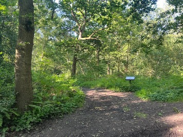
ii. Green Lane looking northeast towards the rifle range and Horsford Woods;
Location & Accessibility: The view is taken from Green Lane looking across the land towards Horsford Woods. It is accessible from Green Lane at the north end of the village walking towards the Cromer Road A140.
Nature & Characteristic in View: This view is representative of the view experienced by people walking, cycling or horse-riding along the lane that runs adjacent to this land. From here you can value the rural setting to the north of the village where the land abuts Horsford Woods. Further development to the east of the village would harm the rural appearance of this particular location and block the skyline of trees and woods.
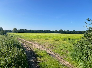
iii. View from Gordon Godfrey Estate to Dog Lane
Location & Accessibility: The view is at the rear of the Gordon Godfrey Estate looking across the Meadow towards Dog Lane. A footpath runs parallel to this meadow.
Nature & Characteristic in View: This view is representative of the view experienced by people walking or cycling along the footpath that runs adjacent to this land and around the rear of the Gordon Godfrey Estate on the Western side of Horsford. From here you can appreciate the marshland and rural setting of the western fringe of the village. Any development would obscure the view and skyline of trees and be harmful to the natural environment.
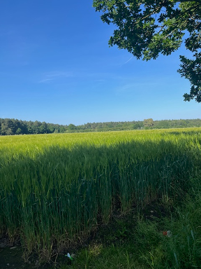
iv. View from Mill Lane East towards Horsford Woods
Location & Accessibility: The view is taken from Mill Lane looking across the land towards the rear of Horsford Woods. It is accessible from the Mill Lane footpath track walking towards Horsford Woods.
Nature & Characteristic in View: This view is representative of the view experienced by people walking, cycling or horse-riding along the footpath that runs adjacent to this land. From here you can appreciate the rural setting of the eastern side of the of the village, where this land lies between Green Lane and Mill Lane. Development would harm the rural appearance of this particular location and block the skyline of trees and woods.
- The views shown above are of particular community significance. To contribute to the rural village feel, residents need to maintain a connection with the countryside within the Parish and beyond. The policy therefore retains this policy from the made Neighbourhood Plan (previously Policy ENV4) which identifies two views from public vantage points, adding an additional two views in the Parish that are considered an important element of preserving the character of the village and the surrounding landscape. Development which would obstruct such a view, or which would lead to a detrimental impact on the view should not be permitted.
- New development can have a significant and detrimental visual impact upon such views and vistas, so any proposals should give consideration to the visual impact of any development, protecting that which is valued. New developments should be encouraged to maintain the rural feel and connection with the countryside. Ensuring key sight-lines, particularly any design element safeguards these views and preserves the vistas as it is highly likely that any building would harm and block or obscure vistas or have an adverse effect to the environment. The location of these views are clearly shown on the Policies Map.