Policy SS2a: Settlement Limit
Policy SS2a: Settlement Limit
- The Neighbourhood Plan allocates 25 Ha of land to the east of the village centre and 11 Ha of land south of Holt Road, as shown on the Policies Map, for a mixed-use development scheme comprising:
- A sports hub on land south of Holt Road for sport and recreation uses;
- A community hub building on land to the east of the village centre for a mix of local community facility uses which must include Class F2(b) space; and
- A facilitating residential scheme on land to the east of the village centre of approximately 300 dwellings comprising open market, affordable and serviced plots for self-build or custom build homes in accordance with Policy HBE1: Mixed Housing and the Greater Norwich Local Plan requirements.
- Proposals must be made in the form of a comprehensive planning application and include:
- An illustrative masterplan developed and agreed with HPC that defines the land uses and key development principles for access, layout, design, and the principles of phasing and implementation taking into consideration the indicative concept plan (Figure 2);
- A delivery plan setting out how the Sports Hub and supporting infrastructure will be secured and delivered;
- A planning obligation to secure:
- the release of the land for the Sports Hub and supporting infrastructure including governance arrangements with HPC, or a nominated appropriate body, under terms required by relevant funding bodies outlined in the delivery plan (ii.) following planning consent and prior to the commencement of that scheme;
- a minimum of 250 square metres ground floor accomodation for Class F2(b) as part of the community hub building of a design and specification to be agreed with HPC, or a nominated appropriate body, including governance arrangements following planning consent and prior to the first occupation of that scheme; and
- other relevant community facilities and infrastructure and financial contributions at appropriate trigger points.
- The Sports Hub scheme shall be confined to land south of Holt Road and the land shall be safeguarded for the provision of sport and recreation facilities and supporting infrastructure for the local community.
- The community hub scheme shall be confined to land to the east of the village centre and comprise either the conversion of the existing barn, or the provision of a single multi-purpose building within the same location if the existing building cannot be converted as part of the enabling residential scheme. In either case the scheme shall be accompanied by appropriate levels of parking and noise attenuation measures to protect the amenity of nearby residential properties whilst allowing the facility to meet a wider range of community needs during the daytime and evenings and on weekdays and weekends.
- The facilitating residential scheme shall be confined to the east of the village centre and shall comprise a mix of dwelling types required by Policy HBE1: Mixed Housing, designed to reflect local character as required by Policy HBE2: Horsford Design Code to sustain and enhance the setting and significance of heritage assets, to provide natural surveillance for the community hub scheme, and planned as an extension of the existing built development edge rather than detached, standalone development parcels. The layout will provide for offset distances and screening to protect the residential amenity of the existing dwellings.
- The application shall be accompanied by an active travel strategy that must include proposals compliant with Policies TRA1: Sustainable Travel and ENV1 Green Infrastructure Network including:
- the delivery of the eastern section of the Green Circular Path which must also operate as an active travel link between the two school sites;
- securing safe and convenient walking and cycling to and between other community facilities and services identified in Policy COM1: Community Facilities and Local Services;
- providing access to the countryside through making connections with existing public right of ways and enabling access to be secured to the Diamond Jubilee Plantation woodland from the site; and
- delivering the road safety measures of the Horsford Transport Masterplan including a safe crossing on Holt Road to the village centre.
- The application shall be accompanied by a transport strategy that must comprise measures to satisfactorily manage the traffic effects of this or any future development on the road network in accordance with the Horsford Transport Masterplan including facilitating gateways and crossings for traffic calming and public realm improvements along Holt Road.
- The application shall be accompanied by a green infrastructure strategy that must make provision for landscape, biodiversity, sustainable drainage, and public open space strategies that demonstrate how existing environmental assets and landscape character will be protected and enhanced. This should include bolstering the green edges of the site, with appropriate planting, retaining or reinstating field boundaries, and locating open space provision as a setting for the community hub scheme. The enabling facilitating scheme must also make provision for community gardens and allotments.
View the allocated land on the Interactive Policy Map
- The allocation of housing here is first and foremost to facilitate the delivery of a number of vital land uses and infrastructure to meet local needs. These include critical community facilities and active travel benefits which cannot otherwise be met. In addition, this provision will increase the contribution of the village to meet the additional local housing needs required by the new mandatory standard method of the Greater Norwich area in the period to 2038. The land for the residential scheme is well located in respect of access to other village facilities and provides an opportunity to complete a Green Circular Path around the village and an active travel link between the two schools. The siting of the Sports Hub to the south of Holt Road, alongside improvements to active travel, ought to relieve some of the pressures faced on the busy Holt Road through the village. It is therefore vital that a masterplan demonstrates how the layout and design of each of the component schemes will fit into and enhance the operation and experience of existing village life.
- The concept diagram shown below are for illustrative purposes only at this stage, there may be different ways in which the scheme components and on-site mitigation measures can be planned, and this will be done at the planning application stage. In any event, the design of the overall layout and distinct schemes will be expected to follow adopted guidance and in combination with the Horsford Design Guidelines and Code ensure that it stiches into the fabric of the village visually as well as functionally.
- The evidence base and site assessment note explain the rationale for selecting this land for allocation. The land presents a generational opportunity to address matters of increasing concern to the local community. The efforts of authorities forming part of the Greater Norwich area, and local sport and recreational clubs and societies, to encourage active lifestyle behaviours and inspire people to become more active has been very successful and has resulted in a critical need for additional sport and recreation facilities. If left unaddressed, there is the potential to undermine that success in future years. A feasibility study undertaken by Broadland District Council in May 2023, published in the evidence base, demonstrates that there is a strong level of need for such proposals
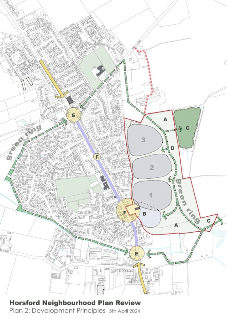
(A) Green infrastructure
(B) Community facilities
(C) Access to woodland and recreation uses
(D) Pedestrian/cycle route linking into the existing route to complete a new Green Ring around the village
(E) & (F) Key elements of the Transport Masterplan
- Whilst the existing village hall remains an important asset well-used by the local community, with historic and the proposed growth of the village, there is a desire for additional community space to contribute to an enhanced village life offer. Both of these additional community facility spaces were supported by the majority of the local community at the most recent community consultation. The Parish Council will seek to agree specifications for the new community space with the developer as the scheme progresses and will help to facilitate the delivery of the new Sports Hub.
- The facilitating residential scheme serves several purposes. Firstly, it makes the land available from its private owner for the community and sports hub schemes. There is no suitable public or other private land available for these purposes. Secondly, it goes some way to assist in meeting the government’s new standard method for local housing need. Therefore, the Parish Council anticipates that, should the Plan be made, the Parish will benefit from the provisions of §14 of the NPPF, or any subsequent replacement in the event that the presumption in favour of sustainable development is triggered. Additionally, the scheme will deliver new active travel links and enable the implementation of traffic management measures to encourage active travel and connection to the open countryside as well as a range of green infrastructure improvements to biodiversity and local nature recovery.
- The policy requires that any planning application that wishes to benefit from its support must be comprehensive in covering all of its elements and must set out precisely how and when the community hub scheme will be delivered and the land for the Sports Hub will be released. This reflects that the facilitating residential scheme must enable the timely delivery and release of land on terms that are acceptable, leaving no prospect that the residential element will be built out and occupied before the community hub scheme is secured and able to operate and the Sports Hub project can commence. This will be done through a planning obligation, which will also secure other elements of the policy, for example its affordable housing. The land interest has confirmed that this approach is reasonable and acceptable.