By post: 3 Rosebery Road, Great Plumstead, Norwich, Norfolk, NR13 5EA
By email: horsfordreg14@gmail.com
Further information on the Plan and its evidence base can be found by clicking on the links below. Alternatively, downloadable copies of the Plan can be found on the Regulation 14 Documents page.
Please note that anyone submitting comments to HPC in response to the Horsford Neighbourhood Plan consultation must provide an email or postal address and contact name. HPC will keep this information confidential. However, as part of the regulations, HPC must forward this information to BDC in due course. For more information, please read our privacy policy.
You can use the links below to explore the draft Horsford Neighbourhood Plan
Further introductory information about the Horsford Neighbourhood Plan is available using the drop down sections below and on the Neighbourhood Plan webpage.
Horsford Parish Council (HPC) is preparing a Neighbourhood Plan Refresh for the area designated by the Local Planning Authority, Broadland District Council (BDC), on 27th April 2016. The area coincides with the Parish boundary (see Plan A on page 12). This document is the second iteration of the original Plan which was made (adopted) in July 2018 and covered the area from 2018 to 2038. BDC has confirmed it is their view that this iteration of the Neighbourhood Plan is extensive and as such, constitutes a new Plan, rather than a modification of the current made Plan. The Plan Refresh is being prepared in accordance with the Neighbourhood Planning (General) Regulations of 2012 (as amended).
The purpose of the Neighbourhood Plan Refresh is to set out a series of planning policies that will be used to determine planning applications in the area in the period to 2038. The Plan will form part of the development plan for the districts of Broadland, Norwich and South Norfolk, alongside the adopted Greater Norwich Local Plan, which runs to 2038, and relevant adopted Development Management and Site Allocations Development Plan Documents. The Growth Triangle Area Action Plan and other adopted Neighbourhood Plans are also part of the Development Plan for the district.
Neighbourhood Plans provide local communities with the chance to manage the quality of development of their areas. Once approved at a referendum, the Plan becomes part of the Council’s Statutory Development Plan and will carry significant weight in how planning applications are decided in the neighbourhood area. Plans must therefore contain only land use planning policies that can be used for this purpose. This often means that there are important issues of interest to the local community that cannot be addressed in a Plan if they are not directly related to planning. Although there is scope for the local community to decide on its planning policies, Neighbourhood Plans must meet all the relevant basic conditions (see overleaf). Community projects/aspirations that the community wish to deliver within the plan period can be referenced under Implementation and Monitoring 6.7.
In addition, the Parish Council will need to demonstrate to an Independent Examiner that it has successfully engaged with the local community and stakeholders in preparing the Plan. If the Examiner is satisfied that it has, and considers the Plan meets the basic conditions, then it is for BDC to ultimately decide whether the Plan will go to a referendum of the local electorate. If a simple majority (over 50%) of the turnout votes in favour of the Plan if sent to referendum, then it becomes adopted as formal planning policy for the neighbourhood area.
The Pre-Submission Plan
This is the opportunity for the Parish Council to formally consult on the proposed vision, objectives and policies of the Draft Neighbourhood Plan (the Pre-Submission Plan). The Parish Council has reviewed the relevant national and local planning policies and assessed how they affect this area. It has also gathered its own evidence, and its reports are published separately in the evidence base.
The Basic Conditions
Does the plan have regard for national planning policy?
Is the plan in general conformity with strategic planning policy?
Does the plan promote the principles of sustainable development?
Has the process of making the plan met the requirements of environmental law?
Does the plan impact on any listed building of buildings of special interest?
Does the plan impact on a conservation area?
Has the plan met the prescribed conditions?
National Changes to the Planning System
During the preparation of this Plan the Government published the Levelling Up and Regeneration Act 2023 with some helpful changes to both the development plan and management system, demonstrating a positive future for neighbourhood planning in the system. Most of the sections directly related to the development plan and management system, particularly the amendment of the basic conditions, have not commenced and will require secondary legislation. This Plan is therefore being prepared ahead of any new system predicted to be implemented. However its content will play a key role in guiding any future decisions which involve changes to Horsford.
Strategic Environmental Assessment & the Habitats Regulations
A Strategic Environmental Assessment (SEA) assesses the environmental implications of a proposed policy or plan. It allows for the cumulative effects of development and policies to be assessed and addresses any identified issues at an early stage. In December 2022, BDC undertook a screening assessment to establish whether the scope of this Neighbourhood Plan Refresh is likely to lead to any significant environmental effects. The screening opinion confirms that the Neighbourhood Plan Refresh is required to prepare an SEA in accordance with the Environmental Assessment of Plans & Programmes Regulations 2004 (as amended). The Parish Council is mindful of the need for the Neighbourhood Plan Refresh to meet the basic conditions, and it has therefore chosen to prepare an SEA as part of a wider Sustainability Appraisal (SA) to consider social and environmental effects as well. A draft SA is published alongside this document.
BDC’s screening opinion also confirms that there are in-combination effects of residential development on designated Habitat sites in the Greater Norwich area. Therefore, a Habitats Regulations Assessment would be required as per the Conservation of Habitats and Species Regulations 2017 (as amended). The Parish Council is obliged to provide BDC with relevant information so that it may carry out its Appropriate Assessment obligations as the ‘competent authority’ defined as such in the aforementioned Regulations. The Parish Council has therefore commissioned an initial report on this matter from consultants, AECOM, which is published alongside this document. BDC’s Appropriate Assessment will be finalised, in liaison with Natural England, as part of the Submission version of this Neighbourhood Plan.
The Next Steps
Once this consultation is complete, the Parish Council will review the comments made, assess where amendments are required, and prepare a final version of the Plan. This will be submitted to BDC for a further consultation and to arrange for its examination by an independent examiner and subsequent referendum, if BDC is satisfied that the draft Plan meets the basic conditions following the examiner’s recommendations.
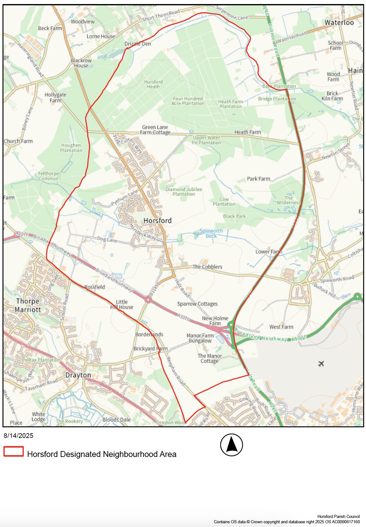
2. The Neighbourhood Area
The Neighbourhood Area
Screenshot
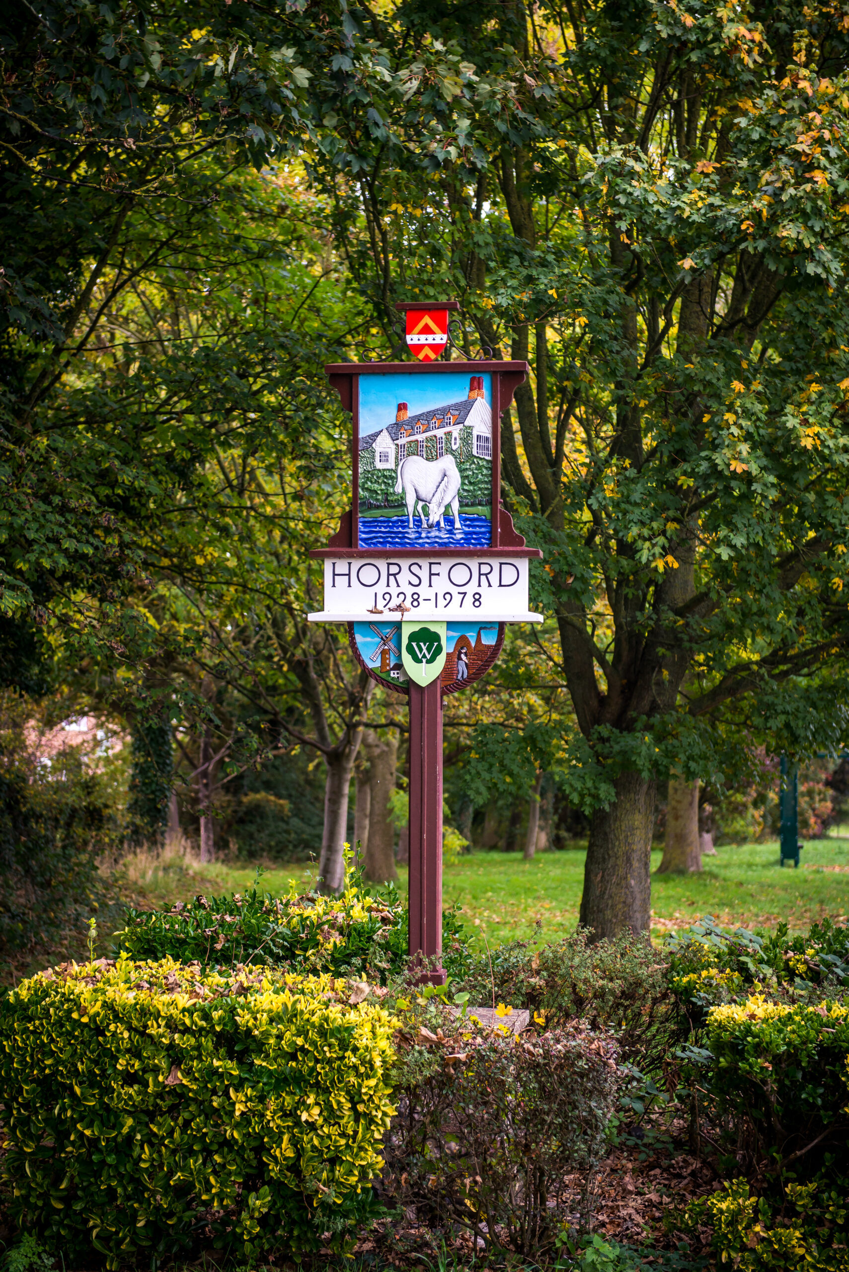
The Parish of Horsford lies within the Norfolk district of Broadland, 10km from Norwich city centre. The B1149 (Holt Road) runs through the middle of the Parish and the Broadland Northway (previously the Northern Distributor Road – NDR) runs through the south of the Parish. The Broadland Northway may have a significant impact on the village. Horsford has a range of shops, a public house, a Post Office and a split site primary school. The Horsford Neighbourhood Plan area covers the same area as the Civil Parish of Horsford.
Land in Horsford is recorded in the Domesday Book. It is thought that the village of Horsford derives its name from the small stream Hor that flows through the village and can be translated from Old English to mean ‘ford over the Hor’ or ‘Ford for Horses’. An alternative suggestion is that it was named after a Saxon by the name of Horsa.
The population of Horsford has seen a steady increase since the Second World War when the population was just 750 in 1945. In the 2011 Census the population of Horsford was recorded as 4163, only a small increase from 3965 in 2001. In the 2021 Census the population was recorded as 4937. The mean age of Horsford is around 45 years compared with 41 years across The East of England as a whole.
The Broadland Northway is a 14km dual-carriage way linking the A47 to the east of Norwich city to the north of Norwich and Norwich International Airport. For Horsford it is a significant change to the road infrastructure linking to wider Norwich and potentially affecting traffic on the B1149 (Holt Road).
3. Planning Policy Context
Planning Policy Context
The Parish lies within the Broadland District (BDC) situated in the county of Norfolk. BDC is the Local Planning Authority for the area. Norfolk County Council is also in the process of agreeing a devolution County Deal. This includes unlocking housing and employment sites and new powers to drive regeneration, housing and development priorities.
National Planning Policy
The National Planning Policy Framework (NPPF) published by the Government is an important guide in the preparation of local plans and neighbourhood plans. The following paragraphs of the latest NPPF version, published in December 2024, and revised in February 2025, are considered especially relevant:
Neighbourhood planning (§29 – §31)
Housing and sustainable development in rural areas (§83)
Sustainable growth of business in rural areas (§88 – §89)
Achieving healthy, inclusive and safe places (§96, §98, §103, §106)
Promoting sustainable transport objectives (§109 – §111)
Creating high quality, beautiful and sustainable buildings and places (§131 – §137)
Proactive approach to mitigating and adapting to climate change (§161 – §162)
Contributing and enhancing the natural and local environment (§187, §192)
Conserving and enhancing the historic environment (§202)
National policy also continues to allow for First Homes Exception Sites to come forward as defined in the PPG (Paragraph: 024 Reference ID: 70-024-20210524 – Paragraph: 029 Reference ID: 70-029-20210524). This is in addition to Rural Exception Sites and Community-led Exception Sites, both of which are defined in Annex 2 of the NPPF. All of these Exception Sites are ‘affordable housing led development’ and Policy 7.4 (see below) of the Greater Norwich Local Plan makes specific policy provision for Affordable housing led development.
National policy now also makes provision for a new mandatory standard method for assessing housing needs. This has resulted in an increase in the number of homes that should be planned for as part of the Joint Plan Area for Broadland, Norwich and South Norfolk over and above that which the recently adopted Greater Norwich Local Plan provided for.
Strategic Planning Policy
The Neighbourhood Plan must be in general conformity with the strategic policies of the ‘development plan’. The ‘development plan’ comprises the adopted Greater Norwich Local Plan (GNLP), Broadland Development Management Development Plan Document (DPD), and three Norfolk Minerals and Waste DPDs.
THE GREATER NORWICH LOCAL PLAN (GNLP)
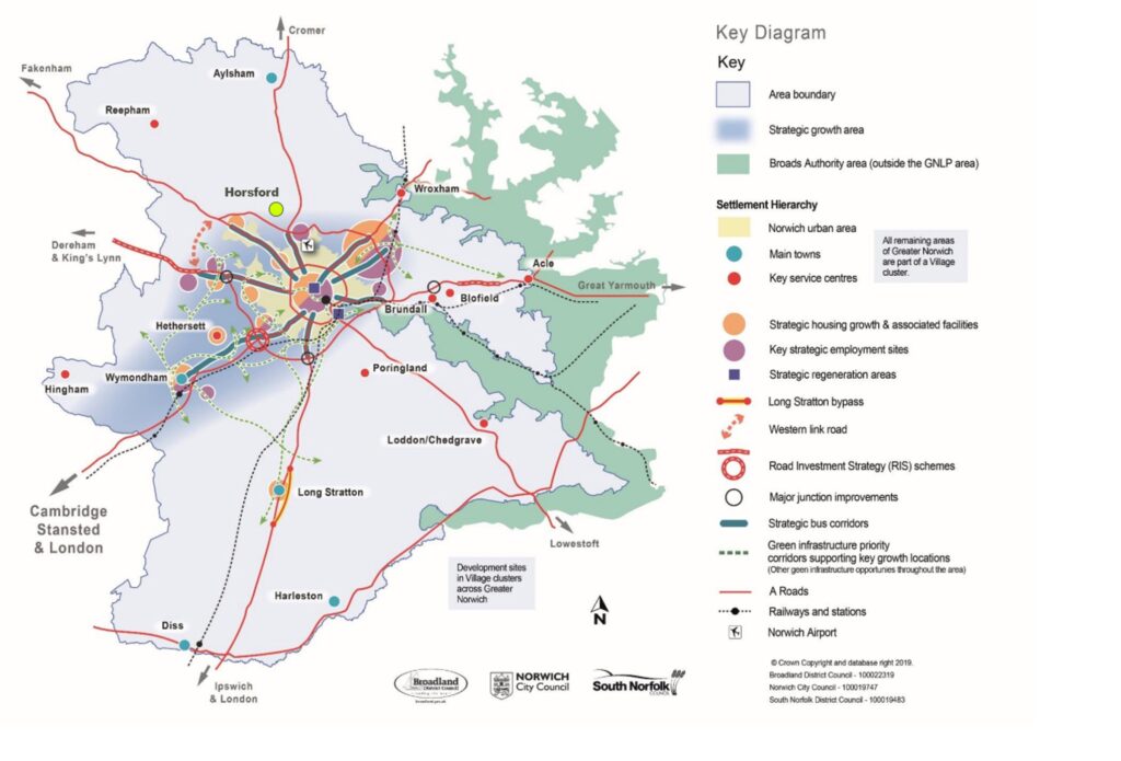
The GNLP was adopted by BDC on 28 March 2024. It provides a strategy for the pattern, scale and nature of development to meet growth needs in the Greater Norwich area. Its Policy 1 sets out a broad strategic growth strategy mostly focussing on the Strategic Growth Area which is illustrated on a Key Diagram (see Plan B). The village of Horsford is located on the edge of the Strategic Growth Area northwest of the meeting point of the A1270 and the A140.
Plan B: Greater Norwich Local Plan Key Diagram
To achieve this strategy the GNLP distributes growth in accordance with a settlement hierarchy. Horsford is identified as forming part of a ‘Village Cluster’. In total Village Clusters are expected to provide a minimum of 3,883 homes across Broadland and South Norfolk. Policy 7.4 supports housing development in Village Clusters in principle and its strategy to achieve the minimum 3,883 figure is through:
1,200 homes from sites allocated in a South Norfolk Village Clusters Housing Allocations Local Plan;
1,187 homes from existing consented commitments on major sites in Village Clusters in South Norfolk;
442 homes from unconsented sites in Village Clusters in Broadland (and it allocates 35 new homes at Dog Lane, Horsford which forms part of this total); and
1,054 homes from existing consented commitments on major sites in Village Clusters in Broadland.
Policy 7.4 also allows for additional residential and small-scale employment development in Village Clusters within settlement boundaries and limited affordable housing led development and self-build and custom build windfall development within or adjacent to settlement boundaries.
Policies 2 – 4 of the GNLP set out how the growth strategy will be supported by improvements to the transport system, green infrastructure and services. It is local improvements to the transport system, green infrastructure and services that remain uppermost in the minds of the local community in preparing this Neighbourhood Plan Refresh.
BROADLAND DEVELOPMENT MANAGEMENT (DPD)
The DPD was adopted in August 2015. It contains a number of development management policies that cover a wide range of matters affecting the Parish, including on the environment, housing, employment, retail, recreation and leisure, transport and safety, community services and utilities and other general considerations. The Neighbourhood Plan Refresh also contains development management policies covering some of these matters and their relationship with existing DPD policies are addressed within the supporting text of each policy in Section 5 of this document.
NORFOLK MINERALS AND WASTE DEVELOPMENT PLAN DOCUMENTS (DPDs)
The Norfolk Waste and Minerals Local Plan 2023-2038 was adopted on 20 May 2025. The Plan continues to define a Minerals Safeguarding Area for sand and gravel which extends across parts of the designated neighbourhood area. This means that future development sites within the Minerals Safeguarding Area will need to address the requirements of the relevant policies to allow for the investigation and assessment of the mineral to ensure that needless sterilisation of a viable mineral source does not take place.
Neighbourhood Planning Policy
There are a number of Neighbourhood Plans which have now been made in the Broadland District. These include neighbouring parishes of Hellesdon and Drayton (both currently being reviewed). Both plans focus on delivering the vision of their respective communities, but there are green infrastructure functionality and connectivity matters which will work across boundaries.
4. Community Views on Planning Issues
Community Views on Planning Issues
The Horsford Neighbourhood Plan Refresh has been shaped by extensive public engagement, including four major consultations between May 2023 and November 2024, which has identified a consistent set of community priorities. These priorities have directly informed the development of the Plan’s policies and land allocations.
The community strongly values the village’s rural character and its distinct identity, separate from Norwich. There is also clear support for the protection and designation of green spaces. While general resistance to further development was noted, there was measured support for schemes delivering tangible benefits—especially improved sports facilities and community amenities.
Residents have expressed a preference for smaller, affordable homes and sheltered accommodation to meet local needs, with any new housing expected to meet high environmental standards, such as Passivhaus principles. Development should also align with the Horsford Transport Masterplan, contributing to improved pedestrian and cycle connectivity and not exacerbating existing traffic concerns.
Key themes that have informed the Neighbourhood Plan include:
Protection of Horsford’s rural identity and landscape setting;
Preservation and designation of valued green spaces;
Support for appropriately located development delivering community benefits;
Need for smaller, affordable and accessible housing;
Requirement for high energy efficiency and sustainable building design;
Alignment with the Horsford Transport Masterplan, including active travel improvements;
Protection of heritage assets and important local views;
Safeguarding existing employment and business space.
These themes have been embedded throughout the Plan, ensuring that its policies reflect the aspirations of Horsford residents and provide a locally supported framework for managing future change. Full details of consultation will be set out in the Consultation Statement that will be published as part of the next stages of the Plan.
The Neighbourhood Plan policies will be implemented through the determination of planning applications for development in the Parish by BDC.
Development Management
The planning authority will use a combination of adopted Local Plans and Neighbourhood Plan policies to inform and determine its planning application decisions. The Parish Council is a statutory consultee on planning applications made in the Parish and it will be made aware of any future planning applications or alterations to those applications by BDC. It will seek to ensure that the Neighbourhood Plan policies have been identified and applied correctly by applicants and by officers in their decision reports.
3. Where necessary, the Parish Council may seek to persuade the Secretary of State to call-in a planning application that it considers is in conflict with the Neighbourhood Plan but which the planning authority has deemed to consent. Similarly, it may also seek to persuade the Secretary of State to recover an appeal of a refused application, where the conflict with one or more Neighbourhood Plan policies has been important in the reasons for refusal. In both cases, the Parish Council will do so if it considers matters of national policy significance (for neighbourhood planning) are raised.
Local Infrastructure Improvements
As there is already a made Neighbourhood Plan, the Parish Council already determines how and where 25% of the CIL collected from schemes in the Parish is spent. Should opportunities arise through S106 agreements or the Community Infrastructure Levy (or through any future Infrastructure Levy) to secure financial contributions to invest in improving local infrastructure, the Parish Council will use the list of local priorities set out in Policy INF1 Developer contributions to inform its decision-making. This is in addition to the infrastructure projects that are proposed to be delivered through site specific policies in this Neighbourhood Plan.
Monitoring & Review
The Parish Council will continue to monitor the effectiveness of the policies in this Neighbourhood Plan through the development management process as set out above. Where necessary, it will engage with BDC to understand decisions made on planning applications or planning appeals. The success, or otherwise, of the policies will feed into the assessment of the need for a future review of the Neighbourhood Plan.
The Parish Council will also assess the need, or otherwise, for a full or a partial review of a made Neighbourhood Plan throughout the plan period. Such assessments will be made:
within five years of the making of the Plan;
within six months of the adoption of a new Local Plan;
if changes to national policy are so significant that they make the policies in the Plan ineffective or out of date;
at the end of the Plan period; and
If significant, local issues arise in the interim which it is felt could be addressed through neighbourhood planning.
Other Non-Planning Matters
During the process of preparing the Neighbourhood Plan, there have been many ideas for improving or addressing current problems in the Parish that lie outside the scope of the land use planning system to control. The Parish Council has noted these issues and will take them forward through its day-to-day business and in partnership with the local community and relevant parties. These include:
Community Benefits
In the future, to implement the community benefits the Horsford Neighbourhood Plan will bring forth, there will be a management structure including the relevant groups in Horsford, such as the Horsford Parish Council, Village Hall Management Committee (VHMC), the Management of the large number of football teams in the village, the FA and Broadland District Council.
It is premature to visualise what that management structure will be but there will be projects that come out of the community benefits on offer and the Business Action Plan Group will be involved as projects emerge.
Sports Hub
Working with the Football teams, FA, BDC and all interested parties to assist with the implementation of the Sports Hub
Community Barn
Working with the community to identify the viable options for the use of the community barn and assist with their implementation.
Highways Issues in Horsford
Traffic Calming
The number of HGVs going through Horsford was the main concern at the November 2024 Showcase and a project based on a feasibility study that will be carried out by NCC Highways will form the basis of a project to try to ease concerns about traffic on the Holt Road.
Puffin Crossing near the Holt Road Primary School
Following on from the successful installation of a Puffin Crossing at the Mill Lane/Holt Road junction, there is a strong desire for a similar crossing to replace the current pedestrian crossing outside of the Primary School on the Holt Road.
No Right Turn, Church Street/Holt Road
This is considered to be a dangerous junction where cars coming from Brewery Lane are competing with cars emerging from Church Street to get out onto the Holt Road. When the new development opposite was built, the bus stop was moved closer to Church Street and cars start queuing back to the Brewery Lane roundabout. This junction will be included in the NCC Highways feasibility study and a project with NCC Highways will emerge from its findings.